Pink Ribbon Trail @ 4M
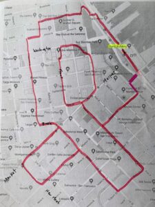
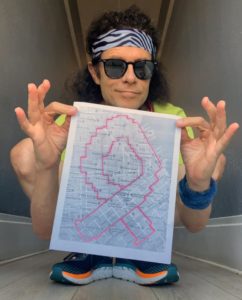
Please join us for the Pink Ribbon Trail – wherever you live – or at the Pinkathon San Francisco! Approximately 4 miles. Created in 2019 by our friend and prolific GPS map artists, Lenny Maughan! Print out and follow the Pink Ribbon Map Below! If you turn on your GPS device or Strava app, you will end up with a trail that looks like a Pink Ribbon! We hope that you will then share your image on Social Media or via email and tell your friends/family how to donate to our charity, the Breast Cancer Research Foundation. Please Register or change your registration to this distance/event (Pink Ribbon Trail) on GiveSignup.org at https://www.givesignup.org/Race/CA/SF/PinkathonSF
Pinkathon.org Pink Ribbon Trail Map & Directions – SF Ferry Bldg


Download Map & Directions Click Here
Turn-by-turn Directions:
START and End in front of the SF Ferry Building, 1 Ferry Building, San Francisco, CA
Google Maps Link:
https://goo.gl/maps/iY2bWmSibAu5ny426
START your GPS app! (Like Strava or Garmin)
South on Embarcadero
R on Don Chee Way
L on Stuart Street
R on Mission Street
R on Beale Street
R on Market Street
L on Drumm Street
At the Drumm Street/Clay Street intersection, run diagonally, NW, through Maritime Plaza Park, to Davis Street/Washington Street intersection.
L on Washington Street
L up the stairs just before the tall (25 floor) One Maritime Plaza office building. Continue South down the steps to Clay Street.
Continue South on Front Street
L on Pine Street
R on Davis Street, cross Market Street, continue on Beale Street
R on Folsom Street
R on 1st Street
L on Market Street
L on New Montgomery
L on Mission Street
L on 1st Street
Cross Market Street, L on Bush Street
R on Sansome Street
R on Jackson Street
L on Battery Street
R on Pacific Street
L at the tennis courts
R on Embarcadero
Continue down the Embarcadero to the Ferry Building to the place you began …
STOP/FINISH your app and see your art!